


ElevMaps
Descrizione di ElevMaps
ElevMaps è un potente strumento GPS con un'interfaccia utente semplice e intuitiva.
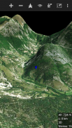
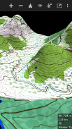
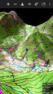
ElevMaps è un visualizzatore di mappe 3D / 2D per le tue escursioni, ma non solo;
ElevMaps è perfetto anche per mountain bike, parapendio e molte attività all'aria aperta ...
Le mappe 3D vengono renderizzate in OpenGL combinando il riquadro della mappa da varie fonti
con dati di elevazione.
Le mappe possono essere visualizzate come una mappa classica (nord in alto) o con rotazione automatica
(Orientamento GPS e orientamento bussola)
ElevMaps è anche un ottimo strumento di navigazione GPS per la mappa ... Non ti perderai mai!
Caratteristiche attuali:
. Visualizza mappe online / offline in 3D e 2D.
. Scarica le aree delle mappe per l'utilizzo offline.
. Visualizza le mappe offline scaricate con Mobile Atlas Creator (MOBAC)
Il formato dell'atlante è l'archiviazione delle tessere OSMAND.
. Visualizza Mapsforge maps / OpenAndroMap maps con diversi temi di rendering.
. Visualizzazione perfetta delle mappe con comandi di livello zoom IN / OUT e integrazione dei gesti delle dita dello schermo.
. Importa e visualizza le mappe di OziExplorer.
. Scarica e allega le quote per le mappe scaricate correnti.
. Utilizza i dati di elevazione nel formato SRTM3 (memorizzati nel dispositivo e perfetti per le mappe grandi)
. Traccia la registrazione in formato KML / GPX.
. Traccia il builder per una facile preparazione dei viaggi in formato KML / GPX.
. Traccia il giocatore con la modalità escursionismo o la modalità aereo 3D in volo (formato KML / GPX)
. Importa / Esporta tracce in formato KML / GPX.
. Finestra delle statistiche (altitudine, velocità, distanza ...)
. Cerca un luogo sulla mappa (necessario Internet)
. E altre funzionalità in arrivo ...
ElevMaps - Versione 1.7.33
(05-01-2025)ElevMaps - Informazioni APK
Versione APK: 1.7.33Pacchetto: org.elevmapsUltima versione di ElevMaps
Altre versioni


App nella stessa categoria

Potrebbe piacerti anche...


